San Francisquito Creek Flood Protection: Bay to Highway 101

The Santa Clara Valley Water District (Valley Water) is a member agency of the San Francisquito Creek Joint Powers Authority (SFCJPA), which is leading a project to protect East Palo Alto and Palo Alto from flooding along San Francisquito Creek between San Francisco Bay and U.S. Highway 101. These communities are at high risk of severe flooding from flows coming down the creek, particularly during high tides. Improving this stretch of about one and a half miles of San Francisquito Creek constitutes the necessary first step in an overall plan to provide more than 5,700 homes and businesses with creek flood protection during extreme tides and after sea levels rise two feet.
Visit sfcjpa.org for comprehensive information on the project and adjoining projects related to the creek and Bay shoreline protection, restoration and trail enhancement.
Construction of Bay-to-Highway 101 Project Status
The construction of flood protection features along San Francisquito Creek that began in 2016 are now complete with major work elements installed, including floodwalls and a significantly wider creek marsh plain. We are continuing work outside the creek channel, including the final phase of installing native vegetation.
Trails and Friendship Bridge are now re-opened
While trails are now re-opened, please keep in mind that some finishing touches to the trails and adjacent areas will be addressed after January 1, 2019. Some work may necessitate temporary closures of certain portions of trails in Palo Alto and East Palo Alto. Upcoming changes will be noted on this site and via project update emails. Sign up for project update notices.
Palo Alto trails:
- East Bayshore Road to Geng Road: Re-opened
- Geng Road to Friendship Bridge: Re-opened
- Friendship Bridge to the Bay: Re-opened
East Palo Alto trails:
- East Bayshore Road to Verbena Drive: Intermittent closure
- Verbena Drive to Friendship Bridge: Intermittent closure
- North of Friendship Bridge: Re-opened
East San Francisquito Creek Trail Intermittent Closure
The San Francisquito Creek JPA's Bay to Highway 101 Project has completed construction of the flood protection features, and the last push to complete the project entails finishing work on trails and vegetation planting.
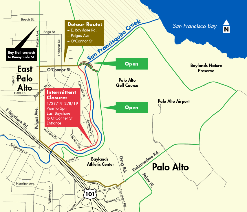
Crews will lay base rock on the pathway from Verbena Drive to Daphne Way and make other grading improvements to the new trail behind the new flood wall. This work will necessitate intermittent trail closures in East Palo Alto from East Bayshore Road to the O’Connor Street entrance. The detour route runs from East Bayshore Road, to Pulgas Avenue extending to O’Connor Street. Please see map below.
Work is scheduled from January 28 to February 8, 2019 from 7 am. – 5 pm., Monday through Friday. This segment of the trail will be re-opened as soon as work is completed.
For your safety, please adhere to all trail signage and fencing.
SFC JPA Celebration of Safety Event on December 14 - First phase of Flood Protection Completed
More than 100 community leaders, elected officials and agency staff braved the rain on Friday, December 14, to celebrate the completion of flood protection improvements on a key section of San Francisquito Creek.
The project is not yet complete; however, the flood protection aspect is finished. There is improved access to trails and existing marsh habitat. A "horizontal levee," also known as a "living levee," slopes more gradually than a typical levee, creates a more natural, gradual transition from the levee to the adjacent marsh. As the sea level rises, the levee will adapt and continue to provide flood protection.
Other improvements include a beautiful boardwalk extension to the popular Friendship Bridge, which will soon be open for use. Also, Caltrans replaced the U.S. 101 bridge to allow for more storm water to flow under the freeway.
Santa Clara Valley Water District Board Member and San Francisquito Creek Joint Powers Authority Chair Gary Kremen said, “It gives me great pleasure to say that this project, from the Bay to Highway 101, which will protect the most vulnerable neighbors of San Francisquito Creek, is now complete. That’s a statement decades in the making.”
“We’re not done,” Kremen added. “This is just one part of the creek that we fixed. The next part, we’re going to be working upstream. You have to do downstream before you do upstream. Things like Pope-Chaucer Bridge, Newell Bridge. Areas within the creek. So we have a lot of work to do on this. It’s all been about partnerships.”
A broad range of distinguished guests spoke at the event: U.S. Representative Jackie Speier, State Senator Jerry Hill, East Palo Alto Mayor Lisa Gauthier, Palo Alto Mayor Liz Kniss, former East Palo Alto Mayor Ruben Abrica, Anne Morkill of the U.S. Fish and Wildlife Service, local resident Dennis Parker, and San Francisquito Creek Joint Powers Authority Executive Director Len Materman.
The $44.5 million construction cost of the Bay to Highway 101 phase of the overall project was funded by Valley Water and many of its partners. Valley Water’s Safe, Clean Water and Natural Flood Protection Program, a voter approved 2012 special parcel tax, provided more than $28 million of the construction funding. Additional funding came from nearly $11.9 million in state grants, along with a combined total of approximately $4.5 million coming from our partner agencies: the San Mateo County Flood Control District and the cities of East Palo Alto, Palo Alto, and Menlo Park.
Because this creek crosses through several city and county jurisdictions, a JPA was formed in 1999, following the devastating flood of 1998. The five members are Santa Clara Valley Water District, the San Mateo County Flood Control District, and the cities of Palo Alto, Menlo Park, and East Palo Alto.
These communities are at high risk of severe flooding from flows coming down the creek, particularly during high tides. Improving this stretch of about one and a half miles of San Francisquito Creek constitutes the necessary first step in an overall plan to provide more than 5,700 homes and businesses with creek flood protection during extreme tides and after sea levels rise two feet.
While the flood protection improvements are in place, work continues on environmental enhancements within the adjacent Faber Marsh. New native vegetation will be installed to provide habitat to the salt marsh harvest mouse and Ridgway’s rail.
The next phase of the project is Upstream of Highway 101. Similar to the first phase, the project will provide 1% (or 100-year) flood protection, ecosystem protection, and recreational benefits. The work being done to the Upstream of Highway 101 will remedy channel constrictions and modify bridges at Newell Road and Pope/Chaucer Street. It will include a combination of: modifications to the University Avenue and Middlefield Road bridges; upstream detention; underground bypass channels; and floodwalls, that could potentially be built. Both the SFC JPA and the U.S. Army Corporation of Engineers are actively working together to develop an environmental documentation that will result in the locally preferred plan.
Updated December 2022