D5: Ecological Data Collection and Analysis*

This project continues to build and update watershed data to track stream ecosystem conditions, helping Valley Water and other county agencies and organizations make informed watershed, asset management and natural resource decisions. The new and updated information will be used to develop or modernize integrated watershed plans (such as watershed profiles, One Water Plan and Stream Corridor Priority Plans) that identify potential projects, support grant applications, environmental analyses and permits, and are shared with land use agencies, environmental groups, and the public to make efficient and coordinated environmental decisions throughout the county. These data and plans will help integrate and enhance Valley Water’s programs, projects, maintenance and stewardship actions through standardized, repeatable and defensible measurements that guide, organize and integrate information on stream and habitat conditions.
Measuring changes in ecological conditions through time allows Valley Water, resource agencies, land managers and the public to understand and respond to climate change effects and evolving creek and habitat conditions.
KPI #1: Reassess and track stream ecological conditions and habitats in each of the county’s five (5) watersheds every 15 years.
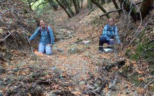
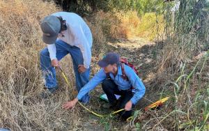
In FY26 Q1 (July 1, 2025 – September 30, 2025), Valley Water and its contractors, San Francisco Estuary Institute/Aquatic Science Center (SFEI-ASC) and SWCA Environmental Consultants, completed the field work for the 10-year reassessment of the Upper Pajaro River watershed using the California Rapid Assessment Method (CRAM). 90 sites were surveyed to capture conditions in the different sub-watersheds: Pacheco Creek, Uvas Creek, Llagas Creek, Pajaro River, and smaller tributaries. During the data collection effort, field crew members participated in calibration trainings to ensure that CRAM data is collected in a correct and consistent manner during the field season. SWCA Environmental Consultants is now entering all of the data and SFEI-ASC will analyze the collected data and prepare the reassessment report later in FY26.
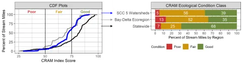
Valley Water uses CRAM to assess the ecological condition of creeks in Santa Clara County’s five major watersheds and document changes over time. You can learn more about the methodology at cramwetlands.org. The CRAM scores that form the basis of the watershed assessments, and for numerous County creeks, lakes, and wetlands, can be accessed on EcoAtlas.
KPI #2: Provide up to $500,000 per 15-year period toward the development and updates of five (5) watershed plans that include identifying priority habitat enhancement opportunities in Santa Clara County.
Valley Water is working with the San Francisco Estuary Institute/Aquatic Science Center (SFEI-ASC) to develop the Upper Pajaro Native Ecosystem Enhancement Tool (UPNEET). UPNEET builds from the One Water Watershed Master Plan for the Upper Pajaro River Watershed to identify more detailed habitat enhancement action and opportunity area assessment and mapping, and utilizes the platform, programming, and structure of the Coyote Creek Native Ecosystem Enhancement Tool (CCNEET – see below for more details). In FY25, SFEI-ASC completed the programming and submitted the beta version of the tool for review by the UPNEET Technical Advisory Committee (TAC), which includes outside technical experts in the fields of wildlife, geomorphology, fisheries, water quality, agriculture, and tribal involvement. In FY26 Q1 (July 1, 2025 – September 30, 2025), Valley Water reviewed and provided comments on the beta version of UPNEET and SFEI-ASC compiled and began to address TAC comments.
Project D5 continues to help maintain and update the Coyote Creek Native Ecosystem Enhancement Tool (CCNEET), an online decision-support tool to identify and coordinate habitat actions to improve ecological conditions along Coyote Creek, from Anderson Dam to Montague Expressway. Inspired by the need for a watershed approach to environmental resource management, project planning, and permitting, an overarching goal of CCNEET is to help coordinate habitat conservation and enhancement so that multiple projects and limited funding can result in meaningful ecological improvement of the creek. CCNEET is now available for use without a username or password. You can learn more about CCNEET here and see first-hand how Project D5 data has been applied to watershed and ecological enhancement planning.
October 2025
For more information:
- Zooey Diggory, (408) 630-2851
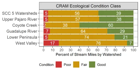
Click here for an enlarged version of the above chart.