
Pre Header

  • FAQ
  • Permits and District Business
  • Valley Water Websites
Home

Main navigation

    • FAQ
    • Permits and District Business
    • Valley Water Websites
  • For Residents
    Highlights
    Access Valley Water
    Easily send requests, reports or feedback directly to helpful district staff.
    Rebates & Surveys
    Programs and rebates helping you save water and money.
    Water Conservation
    Learn the best ways to save water indoors and outdoors.
    Current Water Charges
    Valley Water is funded by property taxes, well owners, agricultural water customers and water retailers like San Jose Water Company
    Emergency & Planning
    Flood Emergency Action Plans
    Drought Information
    Local Hazard Mitigation Plan
    Get Flood Ready
    Preparation for Extended Power Outages
    Alert System Real Time Data*
    Levee Safety
    Save Water & Money
    Rebates & Surveys
    Watersavings.org
    Current Water Charges
    Water Savings Videos
    Indoor Conservation
    Outdoor Conservation
    Projects & Plans
    Projects In Your Neighbourhood
    Creek & River Projects
    Dam & Reservoir Projects
    Grants and Environmental Protection
    Infrastructure Improvement Projects
    Climate Change Action Plan
    Safe, Clean Water and Natural Flood Protection Programs
    Studies and Reports
    Hydraulic Model Data (HEC)
    Stream Maintenance Program
  • Your Water
    Highlights
    Access Valley Water
    Easily send requests, reports or feedback directly to helpful district staff.
    Current Water Charges
    Valley Water is funded by property taxes, well owners, agricultural water customers and water retailers like San Jose Water Company
    Rebates & Surveys
    Programs and rebates helping you save water and money.
    Water Conservation
    Learn the best ways to save water indoors and outdoors.
    Water Sources
    Groundwater
    Imported Water
    Local Dams and Reservoirs
    Recycled and Purified Water
    Where your water comes from
    Information & Resources
    GIS Data
    Glossary of Water Terms
    District Library
    Popular Documents and Data
    Local Dams and Reservoirs
    Water Planning
    Water Supply Master Plan
    Water Supply Planning
    Water Treatment
    Water Treatment Plants
    Water Quality
  • Learning Center
    Highlights
    Access Valley Water
    Easily send requests, reports or feedback directly to helpful district staff.
    Rebates & Surveys
    Programs and rebates helping you save water and money.
    Water Conservation
    Learn the best ways to save water indoors and outdoors.
    Current Water Charges
    Valley Water is funded by property taxes, well owners, agricultural water customers and water retailers like San Jose Water Company
    Learning & Exploration
    Next Gen Career Pathways Program
    Water Education programs and Events
    Water 101 Academy
    Public Tours
    Local Dams and Reservoirs
    Volunteer Engagement
    Volunteer and Engage
    Valley Water Youth
    Commission
    Adopt a Creek
    Grants & Partnerships
    Public Art
    Environmental Science & Conservation
    Healthy Creeks and Ecosystems
    Watersheds of Santa Clara Valley
    The Water Treatment Process
    Aerial Drone Pilot Program
  • News & Events
    Highlights
    District News
    Learn more about the latest headlines and announcements from around the district
    Events
    Find district events happening on variety of topics
    Valley Water News Blog
    Catch up on all the latest list of articles and blog posts
    Videos
    Stay up to date with the latest videos from the district
    Public Records
    Public Records feature many commonly requested documents and data sets.
    Recent News
    Image
    Box culvert in West Little Llagas Creek
    A look at a completed flood wall as part of the Coyote Creek Flood Management Measures Project.
    January 23, 2026
    Valley Water’s annual Capital Improvement Program: Projects to reduce flood risk 

    Editor’s Note: This is the first in a three-part series highlighting some of the projects included in the Capital Improvement Program Fiscal Year 2027-2031 Preliminary Five-Year Plan.

    Read More
    Image
    Valley Water completes erosion repair project along Saratoga Creek in fall 2025
    January 21, 2026
    Providing flood protection through ongoing stream maintenance projects

    Each summer, under the Stream Maintenance Program (SMP), Valley Water takes important steps to protect neighborhoods from flooding. Over time, sediment can accumulate in creeks, reducing their capacity to carry stormwater. During heavy rains, this can lead to an increased risk of flooding for nearby homes, roads and businesses.

    Read More
    Image
    Mockups Design
    January 7, 2026
    Discover how Valley Water is building climate resilience; read the latest biennial report

    Valley Water’s mission is to provide safe, clean water, protect against flooding, and care for local streams. Climate change is affecting this mission. Rising temperatures, changing rainfall patterns, more severe droughts, a declining Sierra Nevada snowpack and rising sea levels all impact water reliability, infrastructure, and ecosystem health throughout Santa Clara County.

    Read More
  • About Valley Water
    Highlights
    Mission, Vision and Values
    Learn about our core mission, vision for the future, and the values that guide us
    Board of Directors
    Meet the board members who provide leadership and oversight for the district
    Finance/Budget
    Access financial information, budgets, and fiscal reports for transparency
    Committees
    Explore our various committees and their roles in district governance
    Board Meetings, Agendas & Minutes
    Review meeting schedules, agendas, and official minutes from board meetings
    Leadership
    Board of Directors
    Board Meetings Agendas & Minutes
    Committees
    Redistricting
    Board Governance Policies
    Accountability
    Public Records
    Lobbyist Ordinance
    Grand Jury Reports
    Enterprise Systems
    Information & Resources
    Finance/Budget
    Capital Improvement Program
    Public Facilities Financing Corporation
    Community Engagement
    Renewed Safe, Clean Water & Natural Flood Protection: Independent Monitoring Committee
    Committees
    Community Partnering Sponsorship Program
  • Services and Support
Loading…
  • Almaden Lake Improvement Project
  • Canal Maintenance Program
  • Lower Berryessa Creek Flood Protection
  • Lower Berryessa Creek Flood Protection (Phase 3)*
  • Upper Berryessa Creek Flood Protection*
  • Calabazas Creek Bank Rehabilitation Project
  • Calabazas/San Tomas Aquino Creek-Marsh Connection Project
  • Coyote Creek Flood Protection*
  • Cunningham Flood Detention Certification
  • Ecological Data Collection and Analysis*
  • FAHCE: Fish and Aquatic Habitat Collaborative Effort
    • FAHCE Final Program Environmental Impact Report
    • FAHCE-Related Board Committee Items
    • FAHCE: Adaptive Management Program
    • FAHCE: Fish Monitoring Program
    • FAHCE-Related Board Agenda Items
    • FAHCE: Certified Final EIR
  • Fish Habitat and Passage Improvement*
  • Flood Risk Assessment Studies*
  • Lower Guadalupe River Project
  • Upper Guadalupe River Flood Protection*
  • Interagency Urban Runoff Program*
  • Upper Llagas Creek Flood Protection*
  • Palo Alto Flood Basin Tide Gate Structure Replacement Project
  • Upper Penitencia Creek Flood Protection*
  • Lower Penitencia Creek Improvements Project
  • Restoration of Natural Creek Functions*
  • Permanente Creek Flood Protection*
  • San Francisco Bay Shoreline Protection*
  • San Francisquito Creek: Bay to Highway 101
  • San Francisquito Creek Flood Protection*
  • Saratoga Creek Hazard Tree Removal and Restoration Project
  • Sediment Reuse to Support Shoreline Restoration*
  • Sunnyvale East and Sunnyvale West Channels Flood Protection*
  • Vegetation Control and Sediment Removal for Capacity*
  • Vegetation Management for Access and Fire Safety*
  • Uvas Creek Levee Rehabilitation

Breadcrumb

  1. Home
  2. Project Updates
  3. E7: San Francisco Bay Shoreline Protection*

E7: San Francisco Bay Shoreline Protection*

Image
Shoreline - Chicago Marsh Cris Benton
Status
Active
Phase
Planning
Location
Milpitas, Mountain View, Palo Alto, San José, Santa Clara and Sunnyvale
Schedule
Start FY 2022 / Finish FY 2031
Funding
Safe, Clean Water Fund ($28.9 million); Watershed Stream Stewardship Fund

This project is a partnership with the California State Coastal Conservancy, the U.S. Army Corps of Engineers (USACE) and regional stakeholders to provide tidal flood protection, restore and enhance tidal marsh and related habitats, and provide recreational and public access opportunities along Santa Clara County’s shoreline.

This project relies on federal participation from the USACE to develop the project and prepare the plans. Without federal participation, Valley Water cannot implement planning, design and construction on our own due to limited available funding. The Safe, Clean Water funding provides a portion of the local share of funding for planning, design and construction phases for Economic Impact Areas (EIAs) 1-4, and a portion of the local share of funding for the planning study and design phases for EIAs 5-9.

The 2012 Safe, Clean Water Program has already provided $15 million as a portion of Valley Water’s  local share of funding for flood protection improvements in Economic Impact Area (EIA) 11, which is the urban area of North San José and the community of Alviso. Once completed, EIA 11 will provide flood protection to more than 1,000 residential structures and 100 non-residential structures, and allow for the restoration of 2,900 acres of tidal marsh and related habitats.

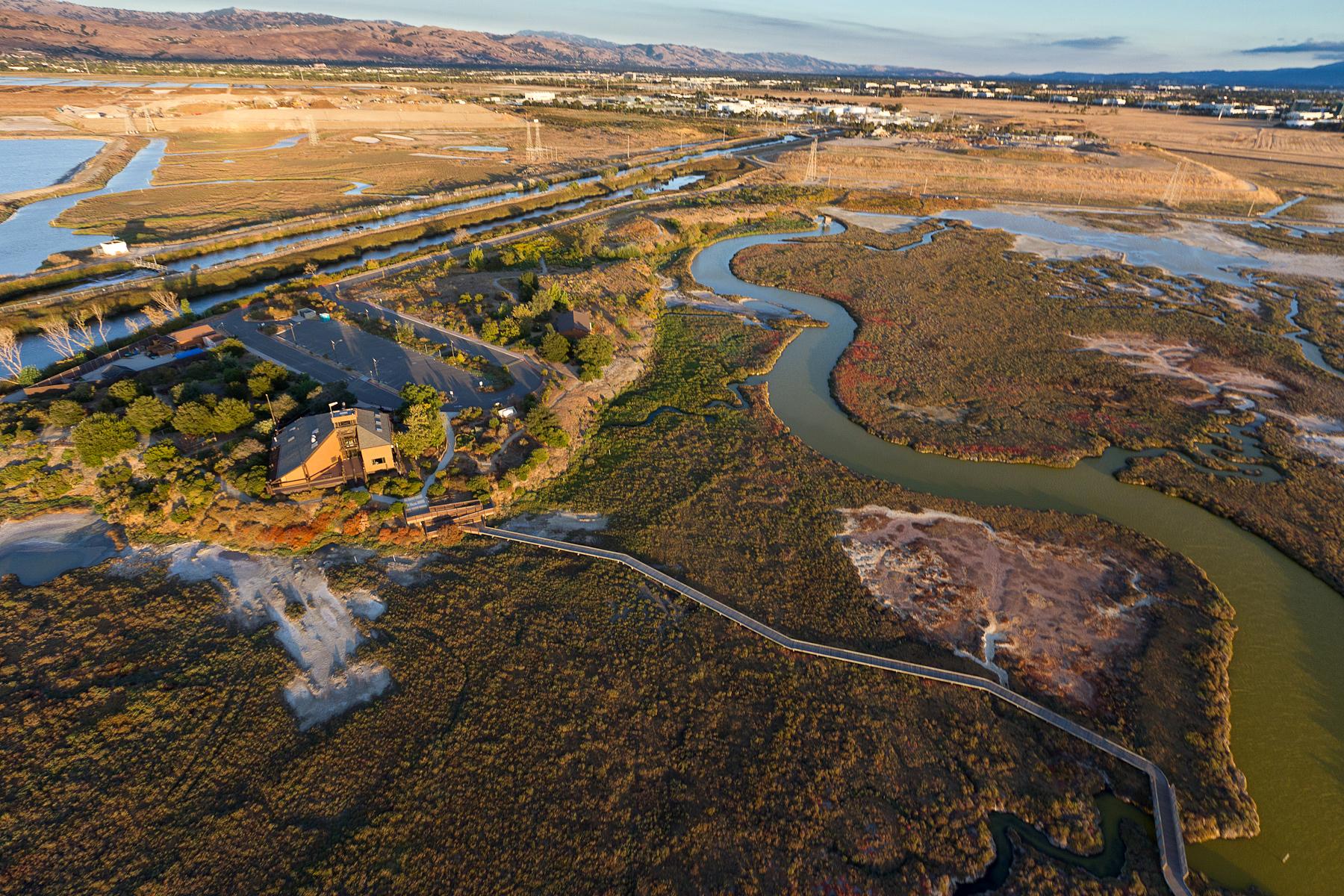
The project will provide coastal flood protection from a rising sea level, and will restore and enhance tidal marsh by using a combination of flood protection levees, wetlands and transitional zone habitats also known as ecotones. Ecotones will provide an additional protective buffer for the levee and allow marsh habitat to migrate upslope as the sea level rises. This approach of using natural infrastructure will help develop a resilient and adaptable flood protection system that can evolve in the future.

(Photograph by Cris Benton)

*This project was voter approved as part of the Safe, Clean Water and Natural Flood Protection Program.

This is a U.S. Army Corps of Engineers (USACE) led project, in partnership with Valley Water, and the California State Coastal Conservancy (Conservancy).  Due to the extent of the project area, the project was split into 11 Economic Impact Areas (EIAs).  Phase I of the project includes EIA 11 in the Alviso area of the City of San Jose.  Phase II focuses on EIAs 1-4, from San Francisquito Creek in Palo Alto to Permanente Creek in Mountain View. Phase III is also known as the Shoreline (Sunnyvale) Feasibility Study and focuses on the remaining EIAs 5-10, from Permanente Creek in Mountain View to Guadalupe River in San José.

Economic Impact Area 11 (Phase I)

Economic Impact Area (EIA) 11 includes the urban area of North San José, the community of Alviso and the San José-Santa Clara Regional Wastewater Facility. There are five reaches under EIA 11 (Phase I). 

To view the map, click here.

Levee construction work on Reaches 1 through 3 began in December 2021 and was successfully completed in Fall 2025. Reach 1 extends from Alviso Marina to the Union Pacific Railroad, and Reaches 2 and 3 stretch from the Union Pacific Railroad to Artesian Slough. Crews have built the Reaches 1 - 3 levee alignment to design elevation 15.2 feet with a 16-foot-wide aggregate base trail on top. 

On September 25, 2025, Valley Water, along with its Project partners, held a milestone celebration event to mark the successful construction of the Reach 1-3 flood risk management levee. 

To view the livestream, click here.

Pond A12 and A13 ecotone construction is scheduled to begin in early 2026, pending approval of the right of entry. Trail closure information will be provided here and will be posted onsite. Similar to the levee construction work, daily construction hours are expected to be 7 a.m. to 5:30 p.m., Monday through Friday, and on weekends if necessary, excluding holidays. During ecotone construction, there will be no public access to trail users across the berms of Ponds A12 and A13, which are within the construction work area. 

To view the previous Reaches 1-3 construction fact sheet, click here.

Reaches 4 and 5, which extend from the Artesian Slough East to Coyote Creek, are in design.

A multi-agency partnership

The Shoreline Project is strongly supported as evidenced by the signing of the USACE Chief's Report in December 2015, with a total Feasibility Study cost of $22 million, followed by its authorization for design and construction in the Water Infrastructure Improvements for the Nation Act in December 2016. 

The total project cost is $545 million to implement coastal flood risk management, ecosystem restoration, and recreational project elements. The project has received $124 million under the USACE 2018 Disaster Supplemental Appropriations Bill. California State Coastal Conservancy’s (Conservancy) and Valley Water’s total local cost share of the project is $309 million. Valley Water’s local cost share is $207 million, and the Conservancy’s local cost share is $102 million. Valley Water has secured $15 million from the 2012 Safe, Clean Water Program, $61 million from the San Francisco Bay Restoration Authority’s Measure AA program, and $14.7 million from a Conservancy grant to support Reaches 1-3 and Reaches 4-5 levee construction, respectively. The remaining share of Valley Water funds will be from the Watershed Stream Stewardship Fund and Senate Bill 881 will allow Valley Water to be eligible for reimbursement from the Department of Water Resources (DWR) State Subventions Program, pending DWR funding availability.  To date Valley Water has secured $21.62 million from DWR. Future federal appropriations of $17 million will be required for restoration monitoring.

For significant EIA 11 project milestones reached, click here.

Economic Impact Areas 1-4 (Phase II)

Economic Impact Area (EIAs) 1-4 include the shoreline areas located between San Francisquito Creek in Palo Alto and Permanente Creek in Mountain View. It includes the communities of Palo Alto and Mountain View.  The Phase II Feasibility Study was concluded in April 2024. See the fact sheet for more information. 

Current activities:

  • Valley Water is considering alternate means of working with local partners or USACE on smaller projects in the study area to address near-term coastal flooding.

Economic Impact Areas 5-10 (Phase III / Sunnyvale Study)

Economic Impact Area (EIAs) 5-10 include the shoreline areas located between Permanente Creek in Mountain View and the Guadalupe River in San Jose.  It includes the communities of Mountain View, NASA, Sunnyvale, San José, and Santa Clara. The Shoreline (Sunnyvale)/Phase III Feasibility Study was initiated in August 2023.

Current activities:

  • The USACE’s next planning milestone, the Vertical Team Alignment Memorandum (VTAM) was approved by the South Pacific Division on March 30, 2025, confirming the study's scope, schedule, and budget. The Additional Resources Request for funding above the standard 3x3x3 planning process is still awaiting approval by USACE Headquarters in Washington D.C.
  • The USACE is beginning work on engineering investigations including geotechnical borings and bathymetric surveys, and continuing to perform hydraulic modeling and economic analysis for the study area.
  • EIA 10: Valley Water is working with the South Bay Salt Pond Restoration Project team to coordinate efforts in EIA 10 (Calabazas/San Tomas Aquino Creek-Marsh Connection Project).

EIAs 5-10 Completed milestones:

  • Valley Water completed a Preliminary Feasibility Study in March 2017 for EIAs 1-10.
  • Valley Water completed a Visioning effort in 2019 in partnership with the San Francisco Estuary Institute, Google, the City of Sunnyvale, Lockheed Martin, the Midpeninsula Regional Open Space District, NASA, the US Fish and Wildlife Service, and the South Bay Salt Pond Restoration Project. The Vision group successfully lobbied Congress for dedication of funds, increased alignment between stakeholders, explored synergies between individual planning efforts, and gathered data USACE will need for their analysis. An executive summary documenting the Vision group’s efforts was finalized in December 2021 and can be accessed here.
  • The Study received federal funding, the Feasibility Cost Share Agreement between Valley Water and USACE was signed, and a kickoff meeting was held in August 2023.  The Conservancy signed on as a local sponsor via an amendment in October 2023.
  • A planning charrette was held in late November 2023 to identify potential project alternatives and a public scoping meeting was held in February 2024. (See link to meeting materials above) to gather public feedback on the study.
  • The Alternatives Milestone Meeting (AMM) Part I was held in April 2024. It included the alternatives that USACE will evaluate as part of the feasibility study.  The AMM Part II was held in October 2024. It included recommended cost and schedule for the study.


December 2025

For more information:

South San Francisco Bay Shoreline Project, Phase I (EIA 11, San Jose / Alviso)

  • Project Questions: Aimee Green, Public Information Representative, (408) 630-2342
  • Sunshine Ventura Julian, Capital Engineering Manager, (408) 630-2273
  • Sign up to receive project updates via email

South San Francisco Bay Shoreline Project, Shoreline Phase II Feasibility Study (EIAs 1-4, Palo Alto / Mountain View)

  • Erin Baker, Capital Engineering Manager, (408) 630-2608
  • Sign up to receive project updates via email

South San Francisco Bay Shoreline Project, Shoreline (Sunnyvale) Feasibility Study (EIAs 5-10, Mountain View / Moffett Federal Airfield / Sunnyvale)

  • Erin Baker, Capital Engineering Manager, (408) 630-2608


Public Notification 

  • San Francisco Bay Shoreline Project flyover
  • San Francisco Bay Shoreline Project Mailer

Project Fact Sheets

  • San Francisco Bay Shoreline Phase II – May 2024
  • San Francisco Bay Shoreline Phase I – March 2025

Economic Impact Area 11

  • EIA 11 Milestones - updated April 2022
  • The USACE Chief's Report is available to download from here.
  • The conformed Board agenda memo for the certification of the Environmental Impact Report (EIR) is available to download from here.
  • The Final Integrated Document consisting of the study’s Feasibility Report and combined EIR/EIS can downloaded from the following links:
    Final Interim Feasibility Study with Environmental Impact Statement / Environmental Impact Report

Appendix A: NEPA/CEQA Supporting Documents 

Appendix B: Supporting Planning and Environmental 

Documentation and Information (Appendix B1-B6 and Appendix B7-B12) 

Appendix C: Economics 

Appendix D: Hydrology and Hydraulics 

Appendix E1: Civil Design and Cost Engineering 

Appendix E2: Basis of Cost Estimate Memorandum 

Appendix F: Monitoring and Adaptive Management Plan for Ecosystem Restoration 

Appendix G: Geotechnical Engineering 

Appendix H: Real Estate 

Appendix I: Public Comments 

Appendix J: Support Letters 

Errata to Final EIR + CEQA Summary 020916

Addenda to FEIR/FEIS:

  • Addendum No. 1
  • Addendum No. 2
  • Addendum No. 3
  • Addendum No. 4
  • Addendum No. 5
  • Addendum No. 6
  • Addendum No. 7
  • Supplemental Information Report to the FEIS: https://www.spn.usace.army.mil/Missions/Environmental/
    • South San Francisco Bay Shoreline Supplemental Information Report June 2023
    • South San Francisco Bay Shoreline Supplemental Information Report Feb 2023
    • South San Francisco Bay Shoreline Supplemental Information Report July 2021
    • South San Francisco Bay Shoreline Supplemental Information Report May 2021
    • South San Francisco Bay Shoreline Project Final Supplemental Information Report Nov. 2020


Economic Impact Areas 1-10

  • The Preliminary Feasibility Study for EIAs 1-10 can be downloaded from the following links:

Executive Summary

Final Evaluation Report

Appendix 1: Long Wave Modeling Report

Appendix 2:  Statistic Analysis of Water Surface Elevation

Appendix 3: Coastal Storm Damage Risk Analysis 

Appendix 4: Hydraulic Analysis


Previous Public Meeting Materials 

  • February 13, 2024: Public Scoping Meeting for the South San Francisco Bay Shoreline Study at Fair Oaks Park Building in Sunnyvale, CA.
    • The U.S. Army Corp of Engineers and Valley Water received community input during a meeting about the coastal flood risk along the South San Francisco Bay.
      • Meeting Recording
      • Presentation


Safe, Clean Water Program Documents

  • FY25 Annual Report
  • All annual reports, annual IMC audit reports and independent audits

FY22-36 Key Performance Indicator for the Safe, Clean Water Program 

  1. Provide a portion of the local share of funding for planning, design and construction phases for the Santa Clara County shoreline area, EIAs 1-4.
  2. Provide a portion of the local share of funding for planning and design phases for the Santa Clara County shoreline area, EIAs 5-9.

Benefits

  • Provides planning and design to protect nearly 4,700 acres and more than 5,000 structures, including roads, highways, parks, airports and sewage treatment plants in Santa Clara County
  • Allows for restoration of tidal marsh habitat for endangered wildlife such as the salt marsh harvest mouse and Ridgway’s rail; rich feeding grounds for shorebirds; and nursery areas for young fish such as leopard sharks and steelhead
  • Provides educational, recreational and public access opportunities
  • Protects more than 4,300 structures (EIAs 1-4)
  • Allows for the restoration of 400 acres of tidal marsh and related habitats (EIAs 1-4)
  • Addresses climate change by providing coastal flood protection from rising sea levels and restoring and enhancing tidal marshes

Geographic Area of Benefit

Milpitas, Mountain View, Palo Alto, San José, Santa Clara and Sunnyvale 

Flooding History and Project Background

This project stems from the 2003 acquisition of thousands of acres of former South Bay salt production ponds, purchased for restoration with combined public and private funding. The South Bay Shoreline Protection Project is an important component of the South Bay Salt Ponds Restoration Project, a large, multi-agency effort to restore 16,500 acres of tidal wetlands which involves all South Bay cities that meet the San Francisco Bay. Without incorporating flood protection measures, proposed recreational use and environmental restoration is likely to reduce the effectiveness of existing shoreline levees formerly maintained for salt production. Project E7 would upgrade levees to protect Silicon Valley’s “Golden Triangle,” bounded by Highways 101, 237 and 880, and extending north into the Baylands of Milpitas. Multiple flood events since the mid-1990s have damaged business operations in this area, now home to major high-tech corporations including Intel, Google, Yahoo, Cisco, and others. The project would also protect Alviso neighborhoods, as well as important infrastructure such as airports and sewage treatment plants.

The existing multi-agency partnerships for the South Bay Salt Ponds Restoration project and the San Francisco Bay Shoreline Study ensure that all goals for this largest wetland restoration on the West Coast will be incorporated. The Safe, Clean Water measure provides a share of the total funding needed for planning and design phases for the full shoreline project area. It also provides the funding needed to purchase lands, easements and rights-of-way as necessary to construct improvements in EIA 11, and a share of the construction costs for that portion of the project.

About the Safe, Clean Water and Natural Flood Protection Program

In November 2020, voters in Santa Clara County overwhelmingly approved Measure S, a renewal of Valley Water’s Safe, Clean Water and Natural Flood Protection Program.

The program was first passed by voters in 2000 as the Clean, Safe Creeks and Natural Flood Protection Plan, then again in 2012 as the Safe, Clean Water and Natural Flood Protection Program. The renewal of the Safe, Clean Water Program will continue to provide approximately $47 million annually for local projects that deliver safe, clean water, natural flood protection, and environmental stewardship to all the communities we serve in Santa Clara County.

While evaluating ways to improve the 2012 program, Valley Water gathered feedback from more than 21,000 community members. That helped Valley Water create the six priorities for the renewed Safe, Clean Water Program, which are:

Priority A: Ensure a Safe, Reliable Water Supply

Priority B: Reduce Toxins, Hazards and Contaminants in our Waterways

Priority C: Protect our Water Supply and Dams from Earthquakes and Other Natural Disasters

Priority D: Restore Wildlife Habitat and Provide Open Space

Priority E: Provide Flood Protection to Homes, Businesses, Schools, Streets and Highways

Priority F: Support Public Health and Public Safety for Our Community

Each year, Valley Water prepares a report providing a progress update for each of these program priorities, along with fiscal year accomplishments.

To ensure transparency and accountability to the voters, the ballot measure also created an Independent Monitoring Committee, appointed by the Santa Clara Valley Water District Board of Directors. The Independent Monitoring Committee annually reviews the program’s progress to ensure the outcomes are achieved in a cost-efficient manner and reports its findings to the Board. Additionally, the IMC also reviews each proposed 5-year implementation plan prior to its submittal for Board approval.

In addition, the program requires three independent audits.

View the Safe, Clean Water Program’s annual reports, annual IMC audit reports, and independent audits, including a staff response, on the Valley Water website.


Footer Top

    Valley Water Logo
  • Report an Issue
  • Contact Us
  • Services & Support
  • Join our Newsletter
    Valley Water Logo
  • Join our Newsletter
  • Report an Issue
  • Contact Us
  • Services & Support

Footer

  • For Residents
    • Water Charges
    • Grants and Rebates
    • Water Conservation
    • Projects and Plans
    • Outdoor Survey
    • Watersavings.org
    • Water Quality
    • Water Supply Planning
  • In an Emergency
    • Get Flood Ready
    • Levee Safety
    • Dam Safety Program
    • Flood Emergency Action Plan
    • Local Hazard Mitigation Area
    • Climate Change Action Plan
  • Data & Resources
    • GIS Data
    • Popular Documents
    • HEC-2 Data Library
    • Surface Water Data Portal
    • Water Sensor ALERT
    • Find My Water Retailer
  • About Valley Water
    • Finance & Budget
    • Board of Directors
    • Board Meetings & Agendas
    • Committees
    • Board Governance Policies
    • Careers
    • Internships
  • In the District
    • Permits
    • Report a Problem
    • Contact Us
    • Purchasing and Contracts
    • Construction Administration
    • Business Resources
  • Learning Center
    • Water 101 Academy
    • Public Tours
    • Adopt a Creek
Santa Clara Valley Water District 2025
Pollution Hotline 888-510-5151
Phone: 408-265-2600