Traffic and Trail Impacts
From time to time our construction and maintenance projects require temporary road or lane closures, trail closures or similar impacts to vehicular or pedestrian traffic. Current and planned impacts will be noticed here.
Current Trail Impacts
Adobe Creek Loop Trail (Palo Alto)
For public safety, a portion of Adobe Creek Loop Trail will be closed from October 6, 2025, to January 31, 2026.
Valley Water will begin construction of the Palo Alto Flood Basin Tide Gate Structure Seismic Retrofit and Rehabilitation Project, as part of our ongoing commitment to providing flood protection. The structure is located where the basin connects to the San Francisco Bay, half a mile northeast of the Byxbee Park parking lot on the Adobe Creek Loop Trail.
During construction, a portion of the Adobe Creek Loop Trail will be closed from October 6, 2025, to January 31, 2026. Flaggers will be present during the mobilization and demobilization of heavy equipment. Thank you for your patience with this temporary inconvenience.
This project is necessary to retrofit the tide gate to reduce seismic vulnerabilities, extend the structure’s service life, and enhance maintenance access. The tide gate structure keeps high tide waters out of the basin while allowing the basin to empty twice during the daily low tides. The tide gate structure is essential in preventing flooding in the lower reaches of Matadero, Adobe, and Barron creeks and inundation of wildlife habitats in the basin.
To view the detour map click here
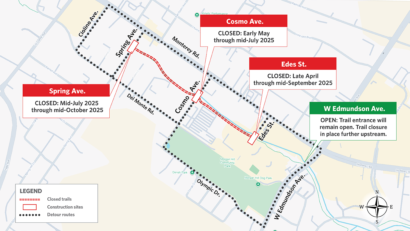
West Little Llagas Creek Trail Temporary Closures (Morgan Hill)
West Little Llagas Creek Trail at Edes St., Cosmo Ave., and Spring Ave. is temporarily closed
For public safety, the West Little Llagas Creek Trail at the above-mentioned streets will be closed to accommodate construction activity beginning the last week of April through fall 2025.
Trail users can access the trail at West Edmundson Ave. and continue south. Del Monte Ave., Olympic Dr., and Monterey Rd. will serve as detour routes. Click here to view the detour map and closure locations.
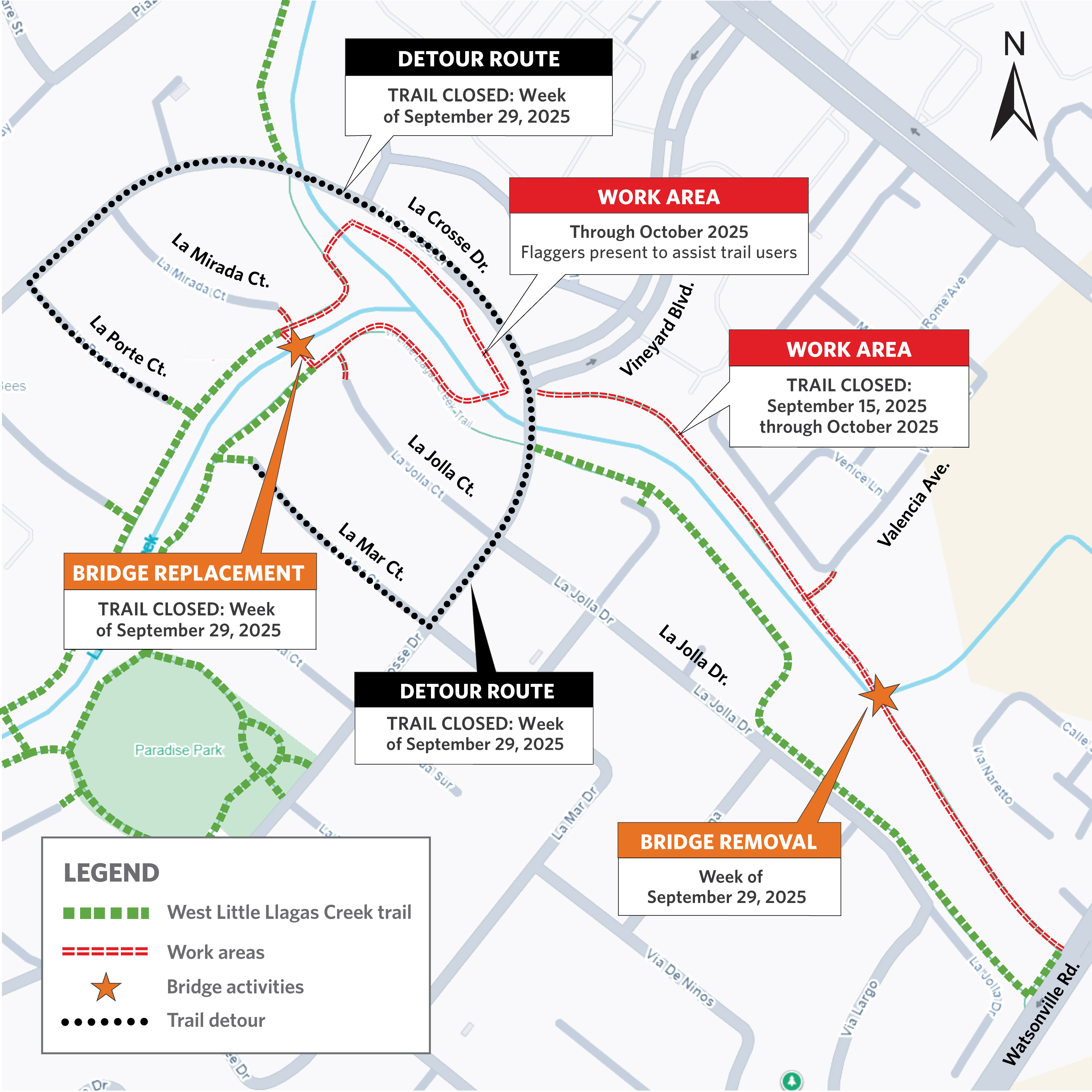
West Little Llagas Creek Trail: La Crosse Dr. to Watsonville Rd.
Starting September 15, 2025, crews will remove vegetation and trees from West Little Llagas Creek from La Crosse Drive to Watsonville Road. While the trail that spans this section of the creek will be closed through October 2025, the south trail that runs parallel will remain open. Please follow the detour shown on the map.
Stream Maintenance Program (2025)
As part of our Stream Maintenance Program (SMP), Valley Water performs work along creeks across Santa Clara County every summer. Under the SMP, work is conducted annually to improve the environment, reduce flood risk, and keep our communities safe. For decades, our crews have been trekking into streams to remove sediment build-up, manage vegetation, clear trash and debris, and stabilize banks that have eroded during high water flows. To download a copy of the 2025 SMP mailer, click here. The 2025 SMP season is done with no further trail impacts for the completed 2025 season.
Current Traffic Impacts
As a safety reminder, please use caution when driving near construction areas and follow all traffic control measures and detours, including signboards, devices, and flaggers, to safely detour nearby drivers and pedestrians.
Hale Avenue Temporary Closure April 14 through October 2025 in Morgan Hill
Work on Hale Avenue continues as part of the Upper Llagas Creek Flood Protection Project. Crews will resume the construction of twin box culverts beneath Hale Avenue, starting from the Morgan Hill Shopping Center and moving towards Wright Avenue. A box culvert is similar to a square-shaped underground tunnel. The two 10-foot wide by 9-foot high culverts will replace West Little Llagas Creek along the eastern side of Hale Avenue to convey a 100-year storm, which has a 1% chance of occurring once a year.
Crews will work from 7:00 a.m. to 8:00 p.m. Monday through Friday and 9:00 a.m. to 6:00 p.m. on Saturdays. Hale Avenue will remain closed through October 2025. Access to the Morgan Hill Shopping Center remains open on Main Avenue, but access from Hale Avenue is only open from the first driveway near the donut shop. The entrance to the Park Plaza Professional Center will be on Crest Avenue. Please see the attached detour map. To learn more about the Upper Llagas Creek Flood Protection Project, visit the project webpage.
Cosmo Ave, Edes St, Spring Ave, and Trail Closures (through fall 2025)
Continuing through fall 2025, Valley Water will construct new box culverts where West Little Llagas Creek crosses under Cosmo Avenue, Edes Street and Spring Avenue. This work requires the temporary full closure of Spring and Cosmo avenues; and a one-lane closure of Edes Street. For public safety, the West Little Llagas Creek Trail on the above-mentioned roads will also be closed.
Construction activity at Edes Street is scheduled from late April through mid-September 2025. Work at Cosmo Avenue is scheduled from early May through mid-July 2025, while work at Spring Avenue is scheduled from mid-July through mid-October 2025.
Visit the project page to learn more about this flood protection project, or click here to view the project mailer with additional details and maps of the street and trail detours.
Crews will work weekdays from 7:00 a.m. to 8:00 p.m. and Saturdays from 9:00 a.m. to 6:00 p.m. when needed. The streets will not reopen until the construction for that section is completed. The anticipated start and end dates for these closures may shift due to unforeseen work conditions.
Spring Avenue in Morgan Hill (June 9 to June 27, 2025)
Starting on June 16, crews will be working on a new sewer line to prepare for Valley Water’s installation of box culverts on West Little Llagas Creek, where it crosses under Spring Ave. to Monterey Rd. One lane of Spring Ave will remain open. The work hours will be from Monday through Friday, 7:00 a.m. to 5:00 p.m., with completion anticipated in 14 days.
At the end of each workday, the lane will be reopened. While work is occurring, turns to and from Monterey Rd. will be limited to the following:
Phase 1: Five days to complete Drivers can turn right onto Monterey from Spring Ave to go southbound and use West Dunne Ave to access northbound Monterey Rd. Left turns from Monterey Rd to Spring Ave will not be allowed. Drivers must use Ciolino Ave to reach Spring Ave.
Phase 2: Eight days to complete Drivers can turn left onto Spring Ave from Monterey Rd. Right turns from Spring Ave to Monterey Rd. will not be allowed, and drivers will need to use West Dunne Ave or Ciolino Ave to access southbound Monterey Rd.
Valley Water will work on additional efforts along Spring Ave. starting in mid-July 2025, which will require the closure of both lanes on Spring Ave. at West Little Llagas Creek and the adjoining trail. Once details are confirmed, additional notice will be provided.